
You are encouraged to share this post with your friends, acquaintances, colleagues and family by all channels available to you.
News posts, such as this, published on the SBARC website are reposted via a number of other channels including social media feeds and our Groups.io mailing lists. These external services may alter the formatting or layout of the original News Post. If you want to see this News Post in its original form please visit the SBARC website News page and follow the link or links to the story or stories of your choice.
Introduction
If you just want to read about the Fram2Ham SSTV Simulation from the ISS please click here. Otherwise please read this page to be better informed about the background and objectives of FRAM2 and FRAM2Ham.
Background
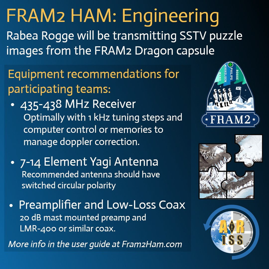
FRAM2 is the first manned flight in low earth polar orbit, flying over both the North and South poles. It will be crewed by 4 astronauts from Europe and Australia: Chun Wang (Mission Commander [Malta]), Jannicke Mikkelson (Vehicle Commander [Norway]), Rabea Rogge (Pilot [Germany]) and Eric Philips (Mission Specialist [Australia]).
The mission will be flown in a SpaceX Dragon vessel.
More information about the mission and the private civilian crew can be found here: f2.com.
Amateur Radio

Full details of the Amateur Radio element of the FRAM2 mission have yet to be published but it is understood that the transmissions will be on 70cm using the Robot36 mode, probably at relatively low power. There will be a competition for schools and other educational institutions for students aged 25 or under.
The Competition
The dates and deadlines for forming teams and potentially alliances have now passed. If you are not entered then it is too late for the competition. It is NOT too late to make plans or preparations to participate in the general receiving of images.
For those taking part in the formal competition, alliances with other institutions to share received images would be a good tactic. Watching social media might also help as many older and unaffiliated hams will probably post their received images.
There will be 12 images of 3 locations sent from the spacecraft, each location being split into 4 partial images. The objective is assemble the 12 partial images into three images and then identify each location. By allying with other institutions elsewhere in the world it will be possible to gather more images than an individual fixed receiver can.
More information about the Amateur radio activities and the competition can be found at either: f2.com/ham or fram2ham.com. There are also specifics about the Amateur Radio requirements accessible from either of those websites here: amapay_user_manual-ver-2-7-2025.
Training Mode

This gets slightly off topic, but the FRAM2Ham operation will be on 70cm where Doppler shift will potentially be ±9kHz compared to the ±3kHz on 2m.
In order to give potential participants the opportunity to test their receiving stations and to hone their skills on lower power signals with switching polarisation, ARISS have organised a brief period of SSTV activity from the ISS. the parameters of this operation are as follows:
- Start Date: 13 February 2025
- Start Time: TBA
- End Date: 17 February 2025
- End Time: TBA
- Downlink Frequency/Mode: 437.550MHz FM (to simulate the likely frequency of the FRAM2Ham transmissions)
- Transmit Power: 5W (to simulate the likely transmit power of the FRAM2Ham transmissions)
- SSTV Mode: PD120 (FRAM2Ham will use Robot36 which takes about 36 seconds to send an image. ARISS have elected to use their regular PD120 mode to allow time during image reception to learn how to adjust polarisation, frequency etc. on the fly)
Orbital Pass Predictions
Address: Novers Park Community Association, Rear of 124 Novers Park Road, Bristol, BS4 1RN
- Latitude (degrees N-S where North is +ve): 51.425358°
- Longitude (degrees E-W where East is +ve): -2.593782°
- IARU (Maidenhead) Locator [Calculated by Spreadsheet]: IO81qk
- Elevation (metres above Ordnance Datum [AOD]): 64m
- What.Three.Words: ///Hugs.Sorry.Dime
AOD: In the UK Ordnance Datum is the mean sea level at Newlyn in Cornwall, elsewhere in the world the elevation above sea-level will be sufficiently accurate.
If you are reading this News post through Groups.io then, due to formatting limitations imposed by Groups.io, the colour banding may not show up in your post. For a full colour correctly formatted version please head over to the SBARC Website News Page and follow the “Read More” link under the headline and description.
Notes:

In the table below:
- Table Entries with a cyan background indicate passes where: 0° < Maximum Elevation ≤ 30°
- Table Entries with a yellow background indicate passes where: 30° < Maximum Elevation ≤ 60°
- Table Entries with a green background indicate passes where: 60° < Maximum Elevation ≤ 90°
- Times are UK clock time, that is GMT/UTC during the winter and BST/UTC+1:00 during the summer
- Elevation shows the degrees above the horizon. Zero degrees is the horizon and ninety degrees is directly overhead
- Azimuth represents the direction to the ISS using a traditional 16 cardinal point compass rose
| Pass No. |
Date | Acquisition of Signal “AoS” | Maximum Elevation | Loss of Signal “LoS” | Pass Duration (Min:Sec) |
Comments | ||||||
|---|---|---|---|---|---|---|---|---|---|---|---|---|
| UK Clock Time | Elevation | Azimuth or Bearing |
UK Clock Time | Elevation | Azimuth or Bearing |
UK Clock Time | Elevation | Azimuth or Bearing |
||||
| 01 | 13/02/25 | 06:26:16 | 10° | S | 06:27:57 | 13° | SE | 06:29:38 | 10° | ESE | 03:22 | Thu – visible |
| 02 | 13/02/25 | 08:00:51 | 10° | SW | 08:04:06 | 49° | SSE | 08:07:23 | 10° | E | 06:32 | Thu – daylight |
| 03 | 13/02/25 | 09:37:24 | 10° | W | 09:40:47 | 85° | N | 09:44:10 | 10° | E | 06:46 | Thu – daylight |
| 04 | 13/02/25 | 11:14:11 | 10° | W | 11:17:32 | 68° | SSW | 11:20:54 | 10° | ESE | 06:43 | Thu – daylight |
| 05 | 13/02/25 | 12:51:17 | 10° | W | 12:53:53 | 21° | SW | 12:56:29 | 10° | SSE | 05:12 | Thu – daylight |
| 06 | 14/02/25 | 07:12:37 | 10° | SW | 07:15:44 | 36° | SSE | 07:18:52 | 10° | E | 06:15 | Fri – daylight |
| 07 | 14/02/25 | 08:48:56 | 10° | W | 08:52:19 | 89° | SSE | 08:55:42 | 10° | E | 06:46 | Fri – daylight |
| 08 | 14/02/25 | 10:25:42 | 10° | W | 10:29:05 | 82° | SSW | 10:32:28 | 10° | ESE | 06:46 | Fri – daylight |
| 09 | 14/02/25 | 12:02:36 | 10° | W | 12:05:35 | 29° | SSW | 12:08:33 | 10° | SSE | 05:57 | Fri – daylight |
| 10 | 15/02/25 | 06:24:32 | 10° | SSW | 06:27:23 | 26° | SSE | 06:30:15 | 10° | E | 05:43 | Sat – visible |
| 11 | 15/02/25 | 08:00:28 | 10° | WSW | 08:03:50 | 77° | SSE | 08:07:12 | 10° | E | 06:44 | Sat – daylight |
| 12 | 15/02/25 | 09:37:13 | 10° | W | 09:40:36 | 88° | N | 09:43:59 | 10° | E | 06:46 | Sat – daylight |
| 13 | 15/02/25 | 11:14:01 | 10° | W | 11:17:12 | 40° | SSW | 11:20:24 | 10° | SE | 06:23 | Sat – daylight |
| 14 | 15/02/25 | 12:53:00 | 10° | SW | 12:53:15 | 10° | SW | 12:53:31 | 10° | SW | 00:31 | Sat – daylight |
| 15 | 16/02/25 | 05:36:40 | 10° | S | 05:39:04 | 18° | SE | 05:41:28 | 10° | E | 04:48 | Sun – visible |
| 16 | 16/02/25 | 07:12:02 | 10° | WSW | 07:15:21 | 62° | SSE | 07:18:41 | 10° | E | 06:39 | Sun – daylight |
| 17 | 16/02/25 | 08:48:42 | 10° | W | 08:52:05 | 84° | N | 08:55:28 | 10° | E | 06:46 | Sun – daylight |
| 18 | 16/02/25 | 10:25:28 | 10° | W | 10:28:47 | 54° | SSW | 10:32:05 | 10° | ESE | 06:37 | Sun – daylight |
| 19 | 16/02/25 | 12:02:57 | 10° | WSW | 12:04:59 | 15° | SW | 12:07:02 | 10° | S | 04:05 | Sun – daylight |
| 20 | 17/02/25 | 04:49:17 | 10° | SSE | 04:50:46 | 12° | SE | 04:52:15 | 10° | ESE | 02:58 | Mon – visible |
| 21 | 17/02/25 | 06:23:39 | 10° | SW | 06:26:54 | 47° | SSE | 06:30:09 | 10° | E | 06:30 | Mon – visible |
| 22 | 17/02/25 | 08:00:10 | 10° | W | 08:03:33 | 86° | N | 08:06:56 | 10° | E | 06:46 | Mon – daylight |
| 23 | 17/02/25 | 09:36:56 | 10° | W | 09:40:18 | 70° | SSW | 09:43:39 | 10° | ESE | 06:43 | Mon – daylight |
| 24 | 17/02/25 | 11:14:01 | 10° | W | 11:16:40 | 22° | SW | 11:19:20 | 10° | SSE | 05:19 | Mon – daylight |
| 25 | No Pass Data | |||||||||||
| 26 | No Pass Data | |||||||||||
| 27 | No Pass Data | |||||||||||
| 28 | No Pass Data | |||||||||||
| 29 | No Pass Data | |||||||||||
| 30 | No Pass Data | |||||||||||
| 31 | No Pass Data | |||||||||||
| 32 | No Pass Data | |||||||||||
| 33 | No Pass Data | |||||||||||
| 34 | No Pass Data | |||||||||||
| 35 | No Pass Data | |||||||||||
| 36 | No Pass Data | |||||||||||
| 37 | No Pass Data | |||||||||||
| 38 | No Pass Data | |||||||||||
| 39 | No Pass Data | |||||||||||
| 40 | No Pass Data | |||||||||||
| 41 | No Pass Data | |||||||||||
| 42 | No Pass Data | |||||||||||
| 43 | No Pass Data | |||||||||||
| 44 | No Pass Data | |||||||||||
| 45 | No Pass Data | |||||||||||
| 46 | No Pass Data | |||||||||||
| 47 | No Pass Data | |||||||||||
| 48 | No Pass Data | |||||||||||
| 49 | No Pass Data | |||||||||||
| 50 | No Pass Data | |||||||||||
| 51 | No Pass Data | |||||||||||
| 52 | No Pass Data | |||||||||||
| 53 | No Pass Data | |||||||||||
| 54 | No Pass Data | |||||||||||
| 55 | No Pass Data | |||||||||||
| 56 | No Pass Data | |||||||||||
| 57 | No Pass Data | |||||||||||
| 58 | No Pass Data | |||||||||||
| 59 | No Pass Data | |||||||||||
| 60 | No Pass Data | |||||||||||